12 min read
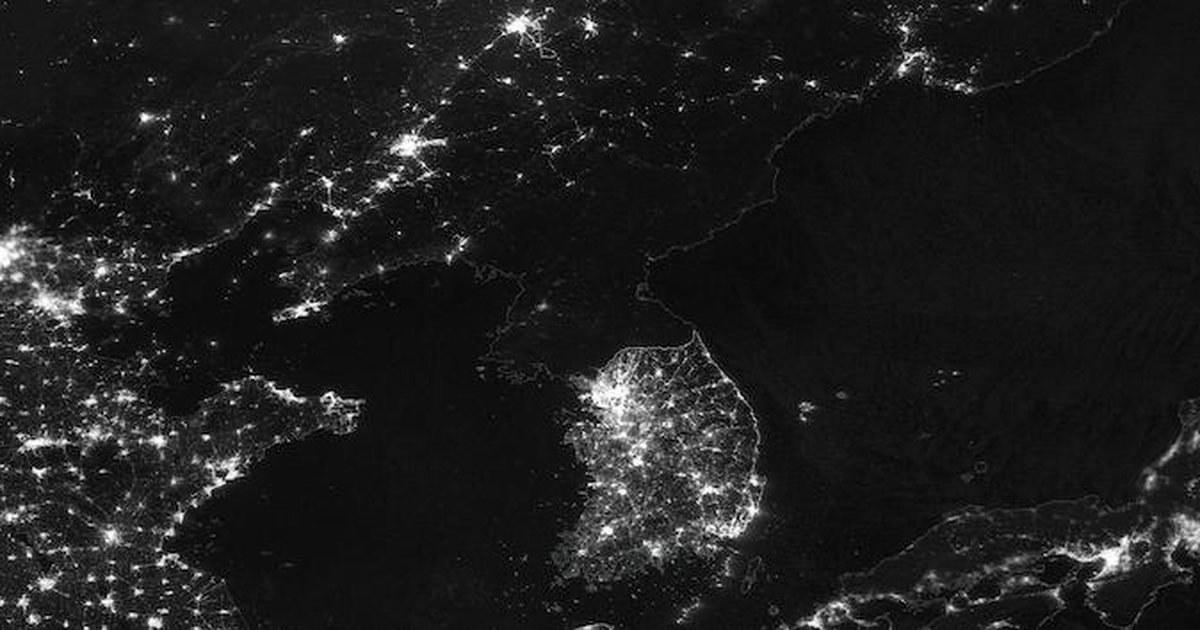
North Korea at night looks nearly black from space. In a 2014 ISS photo, only Pyongyang glows. The reason is simple and it hasn’t gone away: the country doesn’t generate or deliver enough electricity, and what it has goes first to the capital, the military and priority industry. That one picture has become the shortest way to explain the gap between the two Koreas. It is also one of the most misread.
Key takeaways
- The best-known image was shot by astronauts on the International Space Station (ISS) on January 30, 2014, from roughly 400 km up.
- Pyongyang (평양), the capital, is the only big patch of light. Most provincial cities barely show up.
- North Korea’s grid depends on hydropower and coal, and both are unreliable. Much of the equipment dates from the Soviet era or earlier.
- Dark doesn’t mean zero electricity. It means too little, rationed power, much of it used indoors, on batteries or on small solar panels that satellites can’t pick up.
What the famous North Korea at night photo actually shows
Find the full frame and you’ll see the Korean Peninsula with sea on both sides. South Korea is a dense sheet of light, with Seoul as the biggest blaze near the top. Chinese cities glow across the northern border. In between sits North Korea, so dark that you can trace its shape only by where the light stops.
Near the west coast there’s one small, compact island of light: Pyongyang. Almost nothing else in the country comes close. Nobody drew a border on this map. The electricity drew it.
Who took the photo, and is it real?
The crew of ISS Expedition 38 took it with a handheld camera through a station window, and NASA released it in early 2014. It’s a real photograph, not an artist’s render or a composite. The copies that go viral are often cropped, rotated, sharpened or brightened, which is why two versions of “the same” picture can look different. The untouched original is in NASA’s own astronaut photo archive (see the section on finding it yourself below).
The older and newer night images you have probably seen
The 2014 shot wasn’t the first view of a dark North Korea. Since the 1970s, US Air Force weather satellites in the Defense Meteorological Satellite Program (DMSP) have carried low-light sensors, and composites built from their data showed the same pattern. In the 2000s, US officials, then-Defense Secretary Donald Rumsfeld among them, used one of those composites in briefings to make a point about the North’s economy.
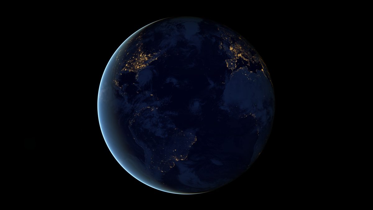
The sharper images today come from the VIIRS sensor (Visible Infrared Imaging Radiometer Suite) on the Suomi NPP satellite, which NASA and NOAA launched in 2011. NASA blends many cloud-free nights of VIIRS data into its Black Marble maps. Because those maps are averaged, they’re a steadier record than a single astronaut snapshot, and they’re what researchers actually measure.
Why North Korea is dark at night: 5 reasons the grid falls short
There’s no single switch that’s been turned off. Five problems pile on top of each other.
1. Too little power is generated in the first place
North Korea’s electricity comes mainly from hydropower dams and coal-fired plants. Hydro output rises and falls with rain and river levels, so it’s strongest after the summer monsoon (the wet season, roughly July and August) and weakest in the cold, dry months, which is exactly when people need heat and light. Coal is mined at home, but the mines need electricity to pump water and run equipment. When the grid is weak, coal output drops, and then the grid gets weaker still.
2. A worn-out grid loses power on the way
Much of the transmission network, the high-voltage lines and transformers that carry power from plants to towns, is decades old. Old lines lose energy as heat, and unstable voltage and frequency can damage motors and appliances at the receiving end. Even when a plant is running, a lot of what it produces never reaches a light bulb.
3. Cheap fuel from abroad dried up
During the Cold War, the Soviet Union supplied oil and spare parts on generous terms. That ended when the Soviet Union collapsed in 1991. Later, UN Security Council sanctions passed in 2017 banned North Korean coal exports and capped imports of refined petroleum. The coal ban took away a major source of foreign currency, and the cap squeezed the fuel that could otherwise run generators.
4. Power is rationed by priority
What electricity there is gets allocated. Pyongyang, military and munitions sites, key factories, and the monuments and leadership sites that matter to the state come first. Provincial towns and villages come last, and outages there are frequent and long. That ordering is the pattern you see from orbit.
5. Little light escapes upward even when the power is on
Satellites see light pointed at the sky: streetlights, car headlights, lit signs, floodlit stadiums, office towers. North Korea has few private cars, sparse street lighting and no neon advertising culture. Homes that do have power often run one dim bulb, so even a town with electricity can look dark from 400 km up.
Pyongyang vs the countryside: who gets the light
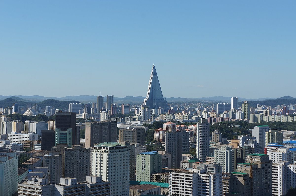
Pyongyang is a showcase city. Living there is a privilege the state controls, and it’s tied to work, party standing and songbun (성분), the family-background classification system the state uses to sort citizens by political loyalty. The capital gets the most reliable supply, the newest apartment towers and the lit-up monuments that visitors and state television show. Even there, outages are widely reported by defectors and foreign visitors. It’s brighter, not guaranteed.
Here’s how the light breaks down across the map:
| Place | What you see at night from space | Why |
|---|---|---|
| Pyongyang (평양) | One compact, clearly visible cluster | First claim on power, showcase buildings and monuments, more street lighting |
| Provincial cities such as Hamhung (함흥), Chongjin (청진), Sinuiju (신의주) | Faint specks, sometimes missing entirely | Lower priority, long outages, few lit roads |
| Rural villages and farmland | Effectively black | Bottom of the queue. Households rely on batteries, candles and small solar panels |
| Chinese border cities, such as Dandong across the Yalu River | Bright, sharp-edged glow | Normal Chinese urban grid and commercial lighting |
| South Korea, especially Seoul and the surrounding area | Dense sheet of light up to near the border | Reliable grid, high-rise living, heavy traffic, lit signs |
| Seas around the peninsula | Scattered bright dots | Fishing boats using powerful lamps to attract squid, not islands or towns |
If you’ve only seen Seoul’s glow from the ground, our guide to things to do in Seoul at night shows what that sheet of light looks like at street level.
How North Korea’s power grid got this way
The dark map isn’t just a recent policy failure. It traces back through a century of building, war and lost patrons. Under Japanese colonial rule, Japan built large hydropower dams and heavy industry mostly in the mountainous north, so at the 1945 division the North actually held most of the peninsula’s generating capacity. Our explainer on Korea under Japanese rule covers that period.
| Period | What happened | Effect on the lights |
|---|---|---|
| 1910 to 1945 | Japanese colonial rule builds hydro dams and industry, mainly in the north | The North starts out with the bulk of the peninsula’s power plants |
| 1948 | North Korea cuts off the electricity it had been sending south | South Korea is forced to build its own generation |
| 1950 to 1953 | Korean War. Power plants and dams are bombed | The grid is heavily damaged and rebuilt with Soviet and Chinese help |
| 1991 | The Soviet Union collapses | Subsidized oil, parts and markets disappear |
| Mid-to-late 1990s | Famine, known in the North as the Arduous March (고난의 행군) | Factories go idle and the grid decays with little maintenance |
| 2011 | Suomi NPP satellite launched with the VIIRS night sensor | Sharper, measurable night images of the peninsula become possible |
| 2014 | ISS Expedition 38 photo released by NASA | The dark-North image goes global |
| 2017 | UN sanctions ban coal exports and cap refined petroleum imports | Less hard currency and less fuel for generation |
One idea runs through all of this: Juche (주체), the state ideology of self-reliance. In practice, self-reliance has meant leaning on domestic coal and hydro and avoiding dependence on imports. That’s a choice that makes sense politically and leaves the grid exposed when the weather or the mines fail.
What the night lights say about North Korea’s economy
North Korea publishes almost no reliable economic statistics. That’s why outsiders reach for proxies, and night light is one of the best known. Economists J. Vernon Henderson, Adam Storeygard and David Weil showed in a widely cited study that changes in satellite night lights track changes in economic output, and that this is most useful where official data is weak or missing. North Korea is the classic case.
The lights do tell you a few things. Economic life and state investment are heavily concentrated in the capital. Provincial industry runs far below what its factories were built for. And the gap with both neighbors is huge.
For a formal estimate, the standard reference is South Korea’s central bank, the Bank of Korea, which publishes an annual estimate of the North’s GDP. Check its official site for the latest figure rather than trusting numbers repeated online.
A worked example: Sinuiju and Dandong
For the clearest single comparison, zoom in on the Yalu River at the northwest border. On the Chinese bank, Dandong shows up as a bright, defined city. Directly across, Sinuiju, one of North Korea’s main trade gateways, is a faint smudge.
Bridges link the two cities and a lot of North Korea’s legal trade with China has passed through here. In this case it’s the same river, the same weather and the same satellite pass. The only real variable is the country, and the brightness gap shows it.
What the lights miss
Much of North Korea’s economy happens in daylight and indoors. The jangmadang (장마당), the informal and semi-official markets that grew after the 1990s famine and now feed much of the population, don’t light up the sky. Neither do the rice paddies, the mines or the small workshops. Night lights measure lighting. They’re a rough proxy for activity, not a census.
How the famous photo gets misread
The image is powerful because it looks self-explanatory. That’s also why people stretch it too far. Six common mistakes:
- “Nobody there has electricity.” Wrong. Power exists but it’s scarce, rationed and unstable. Many households use car batteries and small solar panels, mostly for indoor lights, phone charging and TV.
- “It’s photoshopped.” The 2014 ISS original is a real photograph. Some versions on social media have been edited for contrast, and that exaggerates or flattens the difference.
- “The dark area is empty.” About 25 million people live in that black space. Darkness shows a power shortage, not an absence of people.
- “Brightness equals how rich or happy a place is.” Lighting habits differ. Countries with similar incomes can glow very differently depending on street lighting, urban density and car use. South Korea is especially bright because so many people live in lit high-rise apartment complexes.
- “It never changes.” One photo is one night. Clouds, moonlight, the season and the camera’s exposure all change the result. Multi-year composites show the real trend, and they do move.
- “Those dots at sea are islands.” Most are fishing boats with powerful lamps, a well-known feature of night imagery around Korea, China and Japan.
What we know and what we don’t know
What we know
- Satellite imagery from DMSP, VIIRS and astronaut photography has shown a mostly dark North Korea for decades.
- The grid relies mainly on hydropower and coal, and both are vulnerable to weather, aging equipment and lack of spare parts.
- Pyongyang gets priority supply. Provincial and rural areas get far less.
- UN sanctions adopted in 2017 banned coal exports and capped refined petroleum imports.
- Small household solar panels have spread widely, according to researchers, defectors and foreign visitors, but they’re too small and too indoor-focused to show up from orbit.
What we don’t know
- How much electricity North Korea actually generates and consumes. There’s no trustworthy official data, and outside estimates rely on modeling.
- How much of the power goes to the military and weapons programs compared with homes.
- How far sanctions evasion, such as illicit fuel transfers at sea reported by UN panels, offsets the import cap.
- Whether brighter spots in recent imagery reflect real economic growth or targeted lighting of showcase projects.
North Korean state media, chiefly the Korean Central News Agency (KCNA), presents Pyongyang’s lit skyline and new construction as proof of progress. Treat those as the state’s claims, and weigh them against the independent satellite record. The same caution applies to how information moves inside the country, covered in our guide to whether North Korea has internet.
How to see North Korea at night yourself
You don’t need a research account. Everything below is free from NASA.
- Find the original 2014 photo. Search NASA’s Gateway to Astronaut Photography of Earth for Expedition 38 images of the Korean Peninsula at night.
- Open a night-light map. In NASA Worldview, add a VIIRS night-time or Black Marble layer and center it on Korea.
- Compare years. Use Worldview’s date slider, or the Black Marble stories on NASA Earth Observatory, to put the same area side by side across different years.
- Zoom on three test spots. Pyongyang, the Sinuiju and Dandong pair on the Yalu, and the area just north of Seoul where the light ends near the border.
FAQ
Why is North Korea so dark at night?
It doesn’t generate enough electricity, its aging grid loses much of what it does produce, and the supply is rationed with Pyongyang and priority sites first. It also has very little outdoor lighting, such as streetlights, car headlights and lit signs, so even powered areas give off little light upward.
Is the North Korea at night photo real?
Yes. The famous version is a real photograph taken by the ISS Expedition 38 crew on January 30, 2014, and released by NASA. Some copies online have been cropped or color-adjusted, so compare them with NASA’s original if you want the unedited view.
Does Pyongyang have electricity all the time?
It gets the most reliable supply in the country, but outages there are still widely reported. No reliable public data shows exactly how many hours a day the capital has power. What’s clear from satellites is that it is far brighter than anywhere else in the North.
Can you see the DMZ from space at night?
Not as a line of its own. The DMZ (demilitarized zone), the 4 km-wide buffer strip between the two Koreas, shows up as the edge where South Korea’s lights stop and the North’s darkness begins. The contrast marks the border far more clearly than any feature on the ground.
Has North Korea gotten brighter over the years?
Changes are small at national scale. Most of the variation shows up around Pyongyang and a few border and trade towns. You can check this yourself by comparing Black Marble or VIIRS layers from different years in NASA Worldview.
Why is South Korea so bright compared with North Korea?
South Korea has a reliable national grid, a dense urban population living in high-rise apartments, heavy traffic and plenty of commercial lighting. The two countries started with similar living standards in the decades after the 1950s war. Over time their economies split, and the night map shows how far apart they’ve moved.
What to watch next in North Korea’s night lights
A handful of signals tell you more than any single viral image:
- New NASA Black Marble composites. Fresh annual data is the cleanest way to see whether the North is brightening, and where.
- Summer rainfall. Since hydropower carries so much of the load, a dry year can dim the grid regardless of policy.
- Sanctions decisions at the UN Security Council. Any change to the coal export ban or the fuel import cap would affect generation directly.
- Pyongyang construction projects. New lit districts in the capital can brighten the map without changing anything in the provinces. Read them as showcase investment, not national growth.
- The Bank of Korea’s annual estimate of North Korea’s GDP. It’s the closest thing to an official yardstick to set against the lights. Check its official site when it’s published.
A practical tip: when the 2014 photo turns up in your feed, open the satellite composite for the latest year next to it. If the dark gap between China and South Korea is still there, nothing fundamental has changed.
Related reading
Sources k-korea.blog · eol.jsc.nasa.gov · worldview.earthdata.nasa.gov · earthobservatory.nasa.gov
Prices, opening hours and availability change. Check the official page before you buy or travel.